![]()
![]()
![]()
![]()
![]()
![]()
![]()
![]()
![]()
![]()
![]()
![]()
|
|
|
Bear River Granite Building Stone
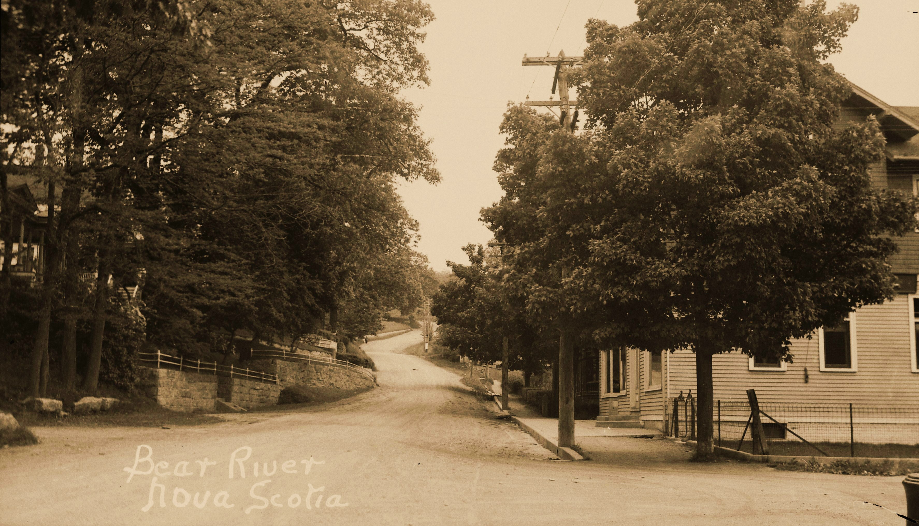
Introduction: Growing up in Bear River, NS in the 1940s and 1950s the presence of light grey granite structural stone was simply a fact of life – it was “everywhere”, the most common presentations being as i) retaining walls or ii) building foundations. The most significant retaining wall was that on the south side of ‘Main Street’ facing the upstream side of the river. That wall stretched from the IOOF hall on the east to the west side of the Post Office, perhaps 200 yards (approximately the distance of the main Cherry Carnival Day footrace!). There were breaks in that wall at the main bridge over the Bear River. Other significant retaining walls were on the north side of the beginning of the Lansdowne Road across from the Dr. Lovett house where it supported the south side of the lot originally housing the Bear River Hotel and subsequently the Darres/Milbury bungalow; behind the telephone office and the Grand Central Hotel; in front of Chester Kaulback’s Guest House, on either side of Mal Parker’s driveway, in front of Mrs. Romans next to Mal Parker; and on the north side of the Oakdene hill between the Anglican Church and the Chute Road corner. A similar wall supporting the former Advent Church parking lot on River Road was removed at the time the Church was dismantled. There were undoubtedly others that I simply do not recall after 65 years! As for the stone’s foundation responsibilities my most vivid memory was its presence in the foundation of the Methodist (United) church at the lower end of Oakdene Hill over which, as janitor for several years, I tried, unsuccessfully, to grow an English Ivy cover. The other two prominent granite foundations in my experience were in the Baptist Church and at our own house (c1920?) at the junction of the Chute and Clementsvale roads. Undoubtedly it was much more widely distributed as a foundation stone (e.g., IOOF hall) but its presence was much more elusive. Perhaps two decades ago as I was compiling an essay on my recollections of the Bear River of the 1940s and 1950s (https://(rayscorner.ca) the question of the source of all that granite became of interest but for whatever reason the geologist in me was satisfied at that time with an offhanded “It came from Greenland” from someone and I never enquired further. Today I have no idea of the source of the “Greenland” notion. In the last few years I have casually reconsidered the source of Bear River’s grey granite, even going to Google Earth looking for quarry sites in Greenland but to no avail. For comparison, the Nictaux Falls granite quarries are conspicuously obvious on Google Earth; however, the Shelburne granite quarries are not visible because of their current treed overstory. In early August 2023 I contacted author Mike Parker, a former Bear River resident, and posed the question to him – “Where was the source of the Bear River granite building stone?” Mike did not know either, but on his way out of 6th Lake a week later he took an hour and photographed several sites in the community hosting the gray granite structural stone. They included the foundation of his grandfather Ralph Purdy’s house up on the west end of Pleasant Street, the Baptist and Methodist church foundations, the retaining wall on both sides of the driveway of his father Mal Parker’s former house, and the retaining wall northeast and uphill from the Anglican Church. What follows is a summary of the past three weeks of computer ‘research’ using currently available on-line information. The research included a review of the various ‘histories’ of Bear River by former local citizens and collected for on-line presentation by Bear River Tides; it involved a reacquaintance with Heritage Remembered, 1981, presented by Bear River New Horizons Center and edited by E Foster Hall; Water Under the Bridge, 2001, by Doug Dockrill under the auspices of The Bear River Historical Society; Oakdene Memories, 2001, compiled by Watson Peck, Family and Friends; and Frontier Town, 2015, by Mike Parker. It also involved a reacquaintance with the updated geology of SW Nova Scotia, some national publications on the mineral production of Canada in the 1920s and 1930s, a couple journeys into stone production in both SW New Brunswick and Vermont, and finally some Canadian census records for both Bear River and Middleton. With the exceptions of photographs of the Bear River waterfront, its main street, and the Methodist and Baptist churches wherein the granite building stone was depicted in place, a referenced connection between the village and granite building stone only occurred once. The assumption must be that the Bear River granite did not have a voice, yet it has been hiding in plain sight for at least 120 years. Maybe this little essay can rectify our collective tendencies to overlook the functionality and ‘stately beauty’ it lent to the village. I am aware that the public is not clamoring for an essay on granite! Hopefully, I can organize the results of the ‘research’ in a way that makes logical sense and at the same time makes it interesting to the reader. Let us see how I do!
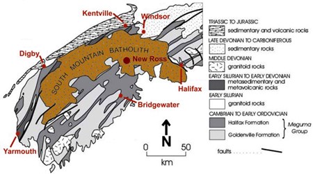
Some Background on Granite: Granite is an igneous rock that is generally composed of the minerals feldspar, quartz, and one or more of dark colored hornblende and biotite mica, and sometimes light-colored muscovite mica. If the feldspar is of the potassium-rich variety the stone may tend to be reddish to pink, otherwise it is usually some shade of grey with the darker varieties reflecting higher concentrations of the dark minerals. It is typically created at depth in the earth’s crust by the melting of former crustal rocks that have been subjected to excessive heat and pressure as they were driven to depth by plate tectonic forces. That molten magma then gets intruded upward within the growing mountain range where it cools and hardens. The granites of southwest Nova Scotia are the exposed intrusive remnants or roots of the former Appalachian mountain range which stretches from central Alabama all the way to Newfoundland. The South Mountain batholith (read large granitic intrusive body) is the largest body of its kind in the Appalachian geological province; structurally it is distributed in an arcuate pattern stretching from the South Kemptville area in the far southwest up toward Bear River, then toward the Wolfville area in the northeast where its boundary bends to the southeast and the Atlantic ocean just south of Halifax. The batholith is more irregular on its southern side than its northern side; it may be some 200km long on its arcuate projection and probably averages some 50 km across. The age of the batholith is generally given at 370 million years.
Geological Map of Southwestern Nova Scotia featuring the South Mountain Batholith (extracted from http://nsminerals.atspace.com/NewRoss.html) (Terance Bay is immediately south of Halifax/Shelburne lies on the coast east of Yarmouth/Nictaux is halfway between Digby and Kentville)
Bedrock Granite in the Area of Bear River: In the Bear River area the NE trending contact of the South Mountain batholith is mapped as passing a few hundred meters north of Barnes Lake, as crossing the West Branch about halfway to Morganville, as crossing the East Branch about a half kilometer north of the Gulch head-pond, as cutting through Fed Lake, and finally as cutting the road just a couple hundred meters west of Virginia East. Most of that boundary is “interpreted” because exposed outcrop is sparse except on the two branches of the Bear River. The most recent geological mapping of the Bear River area is presented in Open File Map 94-07 (1994) by the Nova Scotia Department of Natural Resources as undertaken by L J Ham. That map is most detailed in its presentation, hampered only by a deficiency of outcrop beyond the rivers and streams due to extensive glacial deposits overlying this corner of Nova Scotia. Ham visited and mapped all known mineral deposits in the area, including past producing quarries. Had there been known granite quarries in proximity to Bear River their presence should have been recognized on Ham’s map; no such quarries are shown to exist.
Where Might the Bear River Structural Granite be Otherwise Sourced? In trying to come to terms with this question I reviewed grey granite sources elsewhere in NS, in NB, and in Vermont, the state producing the largest amount of stone in New England. Starting with the Vermont situation I saw nothing in the records that suggested that NS, or specifically Bear River, had been a customer of the quarries of the state of Vermont. Most of the Vermont granite quarries were located upstate in the Barre area, and although they were active early (c1840s) the distance between upstate Vermont and salt water, even if by train, would probably preclude reasonable transportation and handling costs on functional building stone landed in Bear River. The New Brunswick granite sources were sited in two locations. Firstly in the Saint George area of Charlotte County where quarrying was initiated as early as 1872; however, the prime granite varieties from southwest NB were various shades of red and black granite, both marketed for their unique and decorative colors. A second and older (c1842) quarrying area was located near Hampstead on the west side of the Saint John River. That area produced both grey and pink granite for foundation and monument use. However, even with the tradition of shipborne trade between Saint John and Bear River, no evidence has been found to suggest the Bear River grey granite was sourced at Hamstead, NB. Granite quarrying operations in NS have been located in three key areas, i) the Spryfield/Terance Bay area SW of Halifax where grey granite production commenced as early as 1900, ii) the Shelburne/Barrington area of Shelburne County where production of grey granite began in 1890 and black granite by about 1900, and iii) in the Nictaux area of Annapolis County where grey granite production apparently commenced in 1889. Of interest both Spryfield/Terance Bay and Nictaux are located near the boundary of the arcuate South Mountain Batholith. The granites hosted in the Shelburne/Barrington area are not connected on surface to the South Mountain Batholith but appear to be related to the batholith in relative age and chemistry. One of the key elements in bringing structural granite into Bear River would have been the cost of transportation. A Greenland source would have been the most efficient and least costly, particularly because ground delivery would have been all “downhill”! However, in respect of other sources, as pointed out by Mike Parker in one of his e-mails, the most likely means of delivering low valued (~$5.00/ ton in 1933) structural granite to Bear River would have been by water as ships/barges could directly access the core of the village. If we look at potential Nova Scotia sources, water transport from the Terance Bay area of Halifax County or from Shelburne Harbour would have been reasonably efficient. However, in 1914 cart transport from Spryfield to nearby Halifax cost an additional $5/ton in delivery charges. The quarry in Shelburne harbor had the capacity to load ships directly from its adjacent jetty. Early production from Nictaux had the capacity to be moved by train and was reportedly shipped to Annapolis in 1911 for the construction of a church; it could have been moved to the mouth of the Bear River after the DAR rail line crossed the river in 1891. However, such deliveries would have had to be double handled from the train into waiting barges or ox carts, for the 4 mile trip into the village. There is a possibility, but no evidence, that stone may have been moved from the quarry by cart to a suitable location on the Annapolis River and subsequently barged directly into the heart of the village.
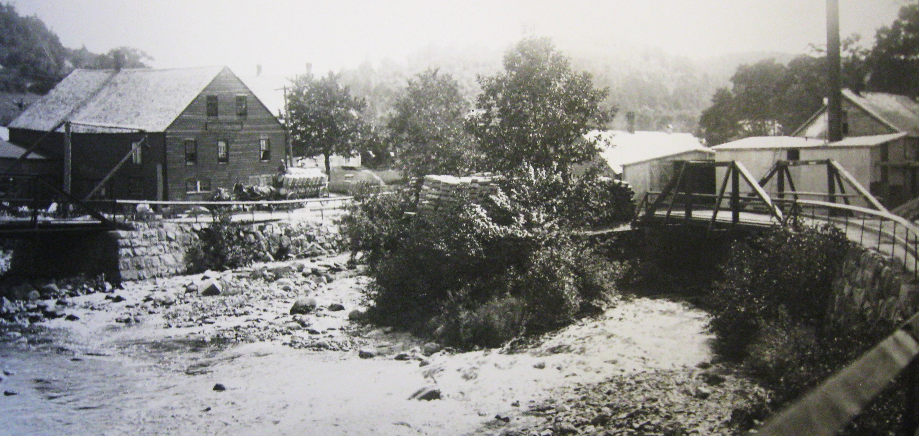
What Do We Know About Granite Manufacturing in Bear River? Frontier Town on p 94 shows a photograph of what is described as Thelbert Rice’s (1858-1934) “Monument Works” dated c1920; it is a large three story building located on “The Flats” immediately west and south of the East Branch bridge. Ina Rice in her 1905 treatise about Bear River makes the following comments about the Monument Works: “The old mill on the east branch of the river was torn down three years ago (c1902) and the one below it was bought by Mr. T. Rice for a tombstone factory.” “In the spring of 1902 the freshet broke away the road and bridges at the head of the tide and Mr. Rice’s Tombstone mill, situated at the foot of the dam was washed out and a number of the nice stones he has polished for sale were swept down the river as well as the buildings, road and bridges. This caused a new road to be built that connected the two bridges, across the two branches that come from the dam”. The details of Ina’s description coupled with the photograph of the Monument Works can be interpreted as follows:
Thelbert Rice’s Monument Works at the Junction of the E and W Branches of the Bear River c1920 (Note the Granite block foundations under both bridges – photo from Frontier Town by Mike Parker, 2015)
*Thelbert Rice purchased a building on the lower end of the East Branch c1902 for a “monument works”. · *There appeared to have been a dam sited immediately upstream of the location which stored water to operate the local streamside manufacturing plants. · *That dam, the building, and both bridges were washed out in a freshet in c1902 and some at least partially finished stones were washed downstream. · *The photo would suggest that T Rice’s Monument Works was reestablished at The Flats on the East Branch adjacent to the river and immediately southwest of the new bridge. · *Of interest, the photo also indicates that the west abutment of the East Branch bridge was constructed of or, at least faced by, at least 5 courses of granite blocks; it also shows that the north abutment of the new West Branch bridge was likewise constructed with granite.
Alveretta I (Rice) Harris stated in “Oakdene Memories”, pub 2001, p 8, in relation to loss to fire of Oakdene Academy in January, 1934: “Time was not lost in starting to rebuild the school. My father Leigh Rice, Mr. Alfred Parker, and Frank Parker, and others I cannot remember, began cutting granite stone by hand for the foundation. This took place at a blacksmith shop owned by Mr. Frank Dunn, located at the bottom of Graham Hill. The building is still there today. Of significance, Alveretta’s statement suggests that in 1934 Bear River was home to large blocks of granite which were capable of being further manufactured into foundation blocks, and the blacksmith work location tends to suggest that Rice’s Monument Works at the head of the tide may have no longer been open.
In looking at some of the individuals with an interest in granite in Bear River we get the following: Thelbert Rice: 1881: 22, living with his father David in Hillsburg, both described as “masons” 1891: 32, married to Hattie S, 30, 2 daughters, described as a “stone man”, one employee 1901: 43, “mason”, married to Hattie, 3 daughters, 1 son Willis; living with family was a William Willis, 45, hired man, “stone cutter”. 1921: 63, “stone cutter”, married to Hattie, 60, son Willis 20, “working for father” (Thelbert died in Pasadena, CA in 1934)
· Leigh/Lee Rice: 1921: living Bear River, “stone carver”. 1931: lodger, living Middleton, “stone carver” at “Monument Works”
· Alfred Parker: 1921: living Bear River, “stone carver” 1931: lodger, living Middleton, “stone carver” at “Monument Works”. (Of interest, I visited the Nictaux quarries c1951 accompanying my friend Alan Parker and his father Carl who had to run an errand to Middleton on behalf of his employer Stewart Darres. We then took “the long way home” by way of the quarries and visited Allan’s grandfather, Alfred [Dean] Parker, at his workplace. About all I can remember were the large number of monument blocks awaiting finishing, and the multitudinous chips of granite scattered everywhere.)
· 1931: lodger, living Middleton, “polisher”
· Willis D Rice: 1931: he and family living Middleton, occupied at “Monument Works”
To provide some perspective on the granite business in NS in the early 1930s the following was extracted from a 1933 mineral production report by the Federal Government: · Granite Production: 1932 – 3,635 tons worth $18,461 or $5.07/ton; 1933 – 8,145 tons worth $36,675 or $4.50/ton
· 1933 NS producers: Shelburne: A R Bower @ Birchtown & Shelburne A T Dauphinee @ Birchtown & Shelburne Nictaux: C M Hoyte @ Middleton Rice Brothers @ Nictaux West/Middleton W D Rice @ Nictaux West/Middleton (no knowledge if Rice operations connected) Various: NS Dept of Highways · 1933 NS employment 75 people
Some Observations of Structural Granite Distribution Within the Village: · The Main Street Upstream “Wall”: o The most prominent (although not the most obvious) use of granite in the village was the slightly north-leaning vertical wall that stretched along and on the upstream (south) side of main street from just upstream of the IOOF hall in the east to the post office of 1950s across from the former Grand Central Hotel. That non-mortared wall was, of course, absent at the Bear River main street bridge with its poured cement abutments. The actual wall probably approximated some 200 yards of length in its two sections. The granite wall had two purposes: i) firstly to provide assistance to the original log cribbing in anchoring in place a significantly backfilled main street, and ii) in adding strength to the upstream side of main street against future river ice of the type that in 1920 ‘took out’ the “iron bridge” of 1886. For the record Heritage Remembered, p 31 provides the following description of Bear River’s backfilled main street:: “Today, the heart of the village, its main street and many of its largest buildings, rest upon a foundation of local logs, overlaid with granite boulders brought in by ox cart and sleigh, …”
o The following photo was extracted from Ina Rice’s 1905 treatise on Bear River. The photo looks north and centers on “the new iron drawbridge” that is reported to have been installed in 1886. Note that east of the small dock on the southeast side of the bridge the main street is buttressed by timber cribbing and not the granite blocks that were in place in the 1950s. If Ina Rice is correct in her bridge identification and its timing (“new”), this suggests that the granite wall on the south side of main street was retrofitted and probably against the timber cribbing. The Captain Anthony building (left edge) has been reported to have been built in 1893 so this photo would probably date in the two first decades of the 1900s and before this bridge was taken out by ice in 1920. Photo of the 1886 “new iron drawbridge” extracted from Ina Rice’s 1905 Treatise on Bear River
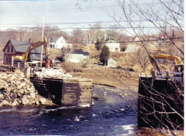
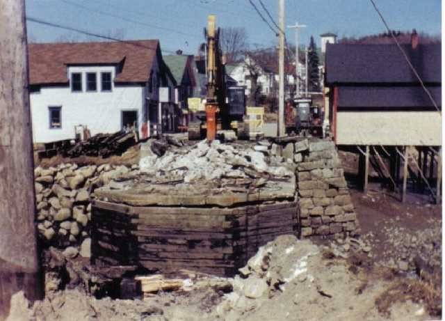
o Records of how and when the wall came to be constructed are currently not available, but speculation aided by some available photos would suggest the following. The granite wall was retrofitted against the preexisting log cribbing that held up main street. It is logical to assume that the retrofit was driven by the loss of the main street bridge in the spring of 1920. The good citizens of Bear River in 1920, even though they had had a Board of Trade in place since 1905, would not have taken on a community project of this size due to cost and needed organizational capacity, but they would have lobbied government for its instillation as part of the bridge rebuild. The community had able leadership in the form of the influential Clarke brothers, who were just in the process of delivering a new pulp mill to the area, and in Bear River’s Dr Lovett, who in 1920 became the district’s Member of Parliament in Ottawa; both were capable of driving home the need for additional protection for both the new bridge and the core of the village’s commercial section. A more recent photo of the granite wall between the former “drug store” and the new (1994) bridge provides for nine visible courses of granite in the wall and speculation would suggest a minimum of at least two more buried in the mud at its base.
Replacing the Bear River main street bridge – 1994 (Note the uncovered granite wall on the N side of the foundation. Note the substantial “wall” on the S side of the foundation.)
o Photos of the 1994 construction of the new Bear River main street bridge were recently provided by Garry Wamboldt; the photo on the left is of the north side of the bridge foundation looking SE, the one on the right looks east with the former drug store on the right. The photos provide two surprises: i) the presence of a formerly buried single-stone granite wall on the north side of the approach to the wooden bridge foundation; and ii) the fact that the wall on the south side was composed not a single sheet of granite blocks but several sheets, the thickness of which decreased from bottom through the 10 or so courses of stone blocks to its top. How far east the granite wall on the north side may have been set is not known. It is assumed that that north wall was retained as part of the construction of the new abutment for the 1994 bridge.
o There were two areas where the granite wall system was used as protection from running water. In the first instance that was at the back of the IOOF hall where ‘Charlie’s brook’ in times of high water could have done some serious damage to an unprotected foundation; and in the second instance a granite wall had been installed on the brook side of George Benson’s meat market to protect the foundation from erosion by a high flowing ‘Campbell brook’ as it coursed the bend just above the bridge.
· Foundations: o The granite foundation in our home at the junction of the Clementsvale and Chute roads was probably typical of those in other houses in the area. The walls are estimated to have been approximately 8 feet high and composed of grey granite blocks perhaps up to 3 feet long and 10-12 inches to a side. With the exception of a small, poured cement block upon which a furnace was mounted, the floor of the basement was soil. The two small windows providing ventilation and light were inset above the granite; one of those windows was used as access for firewood and sawdust fuel. My memory does not include mortar between the blocks. The walls would attract humidity in the summer; however, they would be dry in the winter when the furnace was operating. A recent Mike Parker photograph of the Ralph Parker house at the end of Pleasant Street indicated it too was constructed on a granite foundation. Additionally, one photo of the finished IOOF hall suggests it was built on a granite block foundation as well. I am sure there were many others.
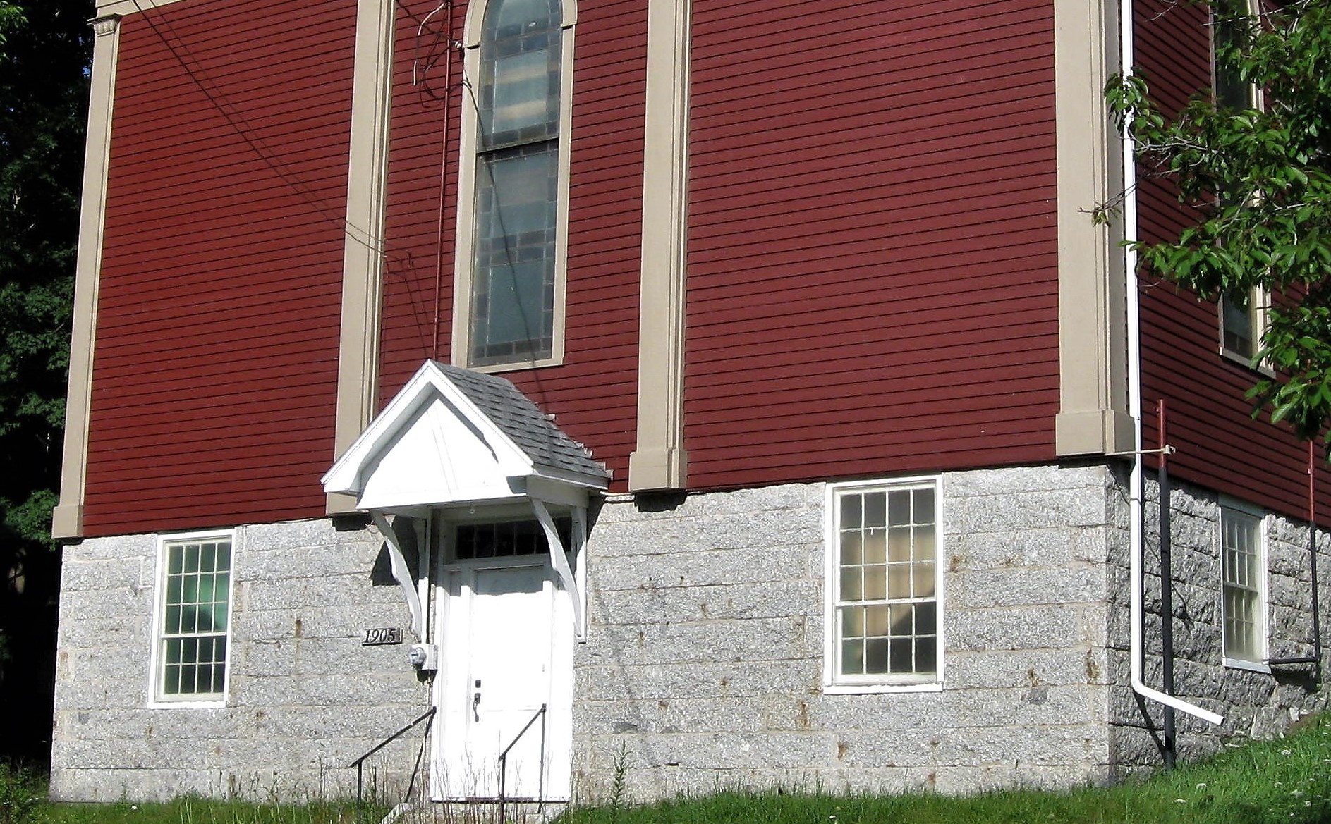
o The granite foundation walls under at least a part of the Methodist and Baptist churches appear to have been designed to provide a strong and stately decorative cache to the two edifices. The Methodist church is given a date of construction of 1856 and the Baptist church 1859. I have come to the opinion that the granite foundations of both churches were retrofitted several decades after original construction. It is likely that the reconstructed post-1934 Anglican church was the recipient of some of the foundation stone mentioned above that was being processed in 1934 for the new Oakdene School.
The Foundation of the former Bear River Methodist Church (Up close the granite is seen to contain large white feldspar crystals and dark inclusions of ‘country rock’. The Baptist church granite also contained large white feldspar crystals but fewer inclusions). Photo by Mike Parker 2023
o Post-1994 photos of the Trading Company and the drug store show granite being used in a different format as a support for the buildings. In the case of the Trading Company that business’ added-on office section, which was extended over ‘Charlie’s brook’, had its south end resting on two (likely four) separate granite supports. Those supports were made by cross-piling pairs of granite blocks of diminishing lengths until the appropriate height for the joist’s was reached. A similar support was emplaced at the southwest corner of the drug store; however, that particular support in my day was sheeted by wooden planks and I was not aware of its granite core until reviewing photos for this essay. The sheeting would have been designed to keep river ice away from the pyramid’s open granite core. Mike Parker’s Frontier Town on page 91 provides the following quote taken from the October 5, 1898 edition of The Telephone, Bear River’s newspaper from 1897 to 1907: “Workmen are at work on the foundation of Messrs. Clarke Bros. office which will form an annex to their store of about forty feet. Stone abutments built from the river bed will form the foundation. One considerably larger than the others will support the vault for the safe.”
o A third type of foundation, again noticed while recently reviewing photographs, was the west side of the post-1902 bridge over the East Branch at The Flats which was mounted on a granite foundation of at least 5 courses of granite blocks. It is assumed that this foundation was laid likely in 1902/03 when the bridge was replaced after the c1902 freshet which had removed its predecessor and Rice’s early monument works. It is not difficult to speculate that Thelbert Rice, whose reconstructed granite works were literally next door, was influential in the use of granite in the new bridge’s foundation.
· Non-river granite supporting walls: o There are a number of granite supporting walls not associated with the river. Perhaps the most visible, and perhaps the most attractive, are those at the foot of the Oakdene Hill which functionally still support the front ‘yard’ of what used to be Kaulback’s guest house, the adjacent walls supporting the front yard and the driveway on the former Malcolm Parker residence, and the granite steps and short wall on what used to be Dr Ellison house and in my day owned by Mrs. Romans (these three houses reportedly all constructed in 1859). Together they added a classy touch to the downtown section of the village. However, I noticed in a recent photo that some of the stones supporting the former Parker driveway have been removed and replaced by functional, but highly unattractive, gabion baskets. Uphill from the Anglican church there is a low granite wall shoring-up the sloping bank of the former Will Brinton property from the street. Recent Mike Parker photos of that wall suggest it is now only a single course of granite overlying field stone; however, my mind tells me that when I walked it 70 years ago it was all granite. Other supporting walls in the village include the wall on the north side of the Lansdowne street across from the Dr Lovett house, and behind the adjacent Grand Central Hotel building and the telephone office. A similar wall supported the parking lot at the front of the Advent church on River Road; however, I’m told it was removed when the building was dismantled. Undoubtedly there were more.
A Ralph Harris c1930’s streetscape looking east up Oakdene hill. (On the left the supporting wall at of Kaulback’s guest house, up the hill is the low retaining wall in front of the Brinton house, at right can be seen the granite foundation under the IOOF hall.)
· Granite as rubble: o On several of the more recent photographs showing the south side of newest (1994) bridge over the Bear River a large, disorganized pile of obviously cut granite stone is shown lying at the join of the poured bridge abutment and the granite block wall that courses westward from under the former drug store. The top of the pile appears to stretch all the way up to street level. This circumstance leads to the questions of why were the stones dumped there and then where might they have originated? It befuddles the mind to assume that manufactured granite blocks would simply be dumped there as waste; rather, one would like to assign them a higher purpose like protecting that join against river ice. As to potential sources three possibilities come immediately to mind i) the blocks represent that stone replaced by gabion baskets in the wall supporting the Mal Parker driveway, or ii) they were stones salvaged from the River Road Advent Church site when the church was demolished, or iii) they were stones salvaged from the hidden wall against the northeast side of the bridge abutment.
Note the manufactured granite blocks used as rubble at the join of the 1994 bridge abutment and main street wall west of the former drug store. (Photo from Bear River website)
OK – So from Whence Cometh the Bear River Structural Granite? After a couple weeks of reviewing published and on-line histories and other information, including recent geological maps of the Bear River area, I am forced to declare I am no closer to a definitive source for the stone than I was three weeks ago. I would so like it to be Greenland, or as a second local choice Morganville; but I came across no supporting evidence. I suspect some of the early (pre-1880) granite monuments at Mount Hope Cemetery were probably cut from local granite boulders because boulders were the usually early feed for the working stone monument masons in NS and elsewhere. However, glacial erratics tend to be generally more difficult to manufacture than “ledge” rock, and the amount of structural stone in BR and its general medium grain and grey color consistency suggest the material would have been quarried. From my casual search of Vermont literature I found no evidence of Vermont stone being shipped to NS. If the Bear River stone came from NB then it most likely had to have come from the quarries near Hampstead on the Saint John River. That location was producing grey granite as early as the 1840s and there was a tradition of active commerce between Saint John and Bear River. However, no evidence was found supporting the granite being sourced at Hampstead. If the Bear River granite was sourced in Nova Scotia there are three known quarry areas that have produced grey granite from which it may have been acquired: i) the Terance Bay area near Halifax, ii) the Shelburne Harbour area, and iii) the Nictaux area of Annapolis county. All three areas were producing by 1890, all three had commercial “ledge” sources of grey granite, all three could have landed granite into the village by water, and after 1891 all three could have landed granite at Bear River station by train. Of these three areas Terance Bay is furthest from the village, Shelburne next, and Nictaux closest and transportation costs would have been a significant factor in sourcing granite for the village. The fact that Bear River’s monument makers, Thelbert Rice and later his son Willis, were producing grey granite stone from quarries in the Nictaux area as early as 1914 and to at least the early 1950s, using Bear River-sourced workers, is probably the best circumstantial evidence we have to suggest Nictaux as the most likely source of the widespread Bear River structural stone. That is not to say that granite may not have been imported from other areas, particularly before 1889; however, that possibility may only be confirmed by a trip (or several) to the Nova Scotia Archives in Halifax. RAR 01/10/23 |